Monday, August 26, 2024

Scientific Progress Goes 'Bonk'?

By Brian Calder


Have you ever seen the "Calvin and Hobbes" cartoon where Calvin builds a duplicator (a cardboard box) and asks Hobbes to push the button to duplicate him?  In just four panels, Bill Watterson manages to capture much of the essence of modern scientific enquiry: scientific ethics, prudence, disputed precedence, experiment, and - crucially - that scientific progress isn't announced by someone in a toga shouting "eureka!" in the street, but, as Hobbes skeptically puts it "Scientific progress goes 'Bonk'?".  I have a framed copy on the wall in my office, and recommend it to all of the students.

We're seeing something similar here in Victoria Fjord, Greenland: there is a marked lack of sediment, and we're not entirely sure why.  Scientific progress here, is starting with "Huh?".

To be clear, I'm not a geologist, although I've worked alongside them for years and have learned just about enough to be dangerous.  But here's the situation: when you have had a glacier growing out into a fjord, you should see lots of sediment left behind as the glacier retreats.  It grinds up and accumulates a lot of sediment as it flows down and into the sea from land, and as the front edge melts back sediment gets washed out.  Huge volumes of sediments are also often deposited by subglacial meltwater during melting and retreat. Sediment should be everywhere, and in the other two fjords (Petermann in 2015, and Sherard Osborn in 2019) it was.

You go looking for sediment, and the record of changing conditions that it captures, initially with a sub-bottom profiling sonar which can image the upper few meters of layered sediments below the ship.  Then, once you've identified a good target remotely, you take a physical sample by coring: you drop a weighted hollow tube (about 12cm diameter, 9 m long and 2000 kg) off the back of the Oden into the seafloor and extract a long, section of sediment, often to many meters depth.  You pull that back up onto the ship, take it out of the liner and then split it so you can preserve part, and make measurements on the other.

But for the last week we've been hunting for sediment, and finding none of note.  Matt O'Regan and his collaborators have even been taking cores every day or so on the most likely targets, and getting very little back for their efforts!  Mostly, there has been a small core returned, and evidence that the corer hit hard till or gravel just below the surface -- in one case even damaging the coring device (it's now repaired and back in business).


Photo credit: Sophie teh Hietbrink

So where's the sediment?  We know that there was a glacier here -- the evidence is all around us -- but either it didn't drop any sediment (which is almost impossible to believe), or that sediment got washed away somehow by a mechanism or mechanisms unknown, and contrary to what happened in Sherard Osborn Fjord, which is literally right next door.  Since the two glaciers have essentially the same source, it's also pretty unlikely that the conditions in the glacier would be so different (in terms of how much sediment they contain), so there must have been sediment at one time.  But then if it was going to be washed away you'd expect that the smaller, finer sediment components would have been washed out more than the coarser sediments, and you'd still see the residuals.  And we haven't, yet.

Photo credit: Jon Persson

It's a bit of a mystery, but that's the essence of scientific investigation: although we know a lot about the world and how it works, there's always something new to learn, and new explanations to find.  It's not always comfortable when you find something new and exciting, and it's often painful when your beautiful theory goes up in a puff of smoke in the face of new evidence.  But the drive to explore, to understand, is at the core of what makes us human, and that's why we keep doing it, even when it means a long time away from our homes and families in a remote part of the world.

As Carl Sagan used to say "Extraordinary claims require extraordinary evidence".  So we better get back to collecting some more evidence -- there's another core scheduled for today, in a nice juicy target we saw on the overnight sonar watch last night.  Keep your fingers crossed; listen for the "bonk" – or if you’re on the back of the ship coring, hopefully not.


**Geology validated by a real marine geologist, thanks Matt!

Wednesday, August 21, 2024

It’s like herding cats: Multi-investigator scientific expeditions

Written by Liz Weidner


Icebreaker Oden is big: 107.7 meters long and 25 m wide at the midship, with eight decks and an endurance of more than 100 days. GEOEO fills every single bunk on Oden. Twenty-three crew members are responsible for its running, maintenance, and upkeep, as well as the safety of the science personnel on board. The science team comes in at fifty-two individuals: thirteen from the Swedish Polar Research Secretariate (SPRS) and the rest are researchers from more than ten institutions. Perhaps not surprisingly, the scientific goals for the GEOEO expedition are far ranging: from our efforts to map the seafloor of Victoria Fjord to characterizing Arctic Ocean circulation through collection of ancient driftwood to studying microscopic marine organisms collected with “bongo nets”.

Every person on Oden, scientist or otherwise, answers to the Captain, Erik Andersson, for any matter, at any time. Beyond that, the science team is organized under the Co-Chief Scientists, Martin Jakobsson and Nina Kirchner, who are in regular discussion with the crew and SPRS personnel to define the activities of the day (the captain has the final say). Under the Co-Chief scientists, the scientific team of GEOEO is spilt into a series of Work Packages (WP), each with their own Principal Investigator (PI) or Investigators. Each WP consists of a team of scientists at variable career stages (professors, researchers, technicians, graduate students, postdocs), who contribute to the data collection and analysis for the WP.

There are ten work packages on GEOEO:
  1. Marine Geophysical Mapping
  2. Glacier-Ocean Observatory
  3. Silicate Alteration in Marine Sediments
  4. Sediment Coring and Processing
  5. Interactions between North Greenland Ice Sheet and Atlantic Water
  6. Palaeogenomics of Ecosystem Change
  7. Improved Analyses of Arctic Climate Change
  8. Trace Gas Dynamics and Pelagic Ecosystem Functions
  9. Tectonic Evolution of North Greenland
  10. Arctic Meteorology and Ocean Surface Exchanges

As you can probably imagine, it is an enormous task to keep progress moving forward for ten different WPs, manage the expectations of multiple PIs, allocate the daytime working hours, and deal with continually changing ice and weather conditions, all while making sure everyone is safe and getting at least a minimal amount of sleep. Just to add to the complexity, Oden carries two helicopters for terrestrial and ice-based work (primarily for WP2, WP6, and WP9). The helicopters have limited space (in theory you can fit five passengers plus the pilot, but it’s a tight squeeze), limited fuel, and very specific weather windows. They add another piece of the ever-expanding puzzle of GEOEO operations. As you can start to see, multi-investigator science is a lot like herding cats!


During a typical day on Oden a series of meetings occur to keep operations running smoothly:

Leadership meeting: These occur every morning on the bridge at 7:00 am and consists of the captain, the Co-Chief Scientists, and SPRS personnel (including the meteorologist). They discuss the current ice conditions, which define where Oden can and cannot go and what operations can and cannot happen. Weather is a regular topic of discussion, as bad weather or high winds can ground helicopter operations and small boat deployments. Time left in the expedition is always a point of discussion. You might be surprised to hear this, as we aren’t even halfway through! But right from the start, everyone on board does there best to squeeze out as much data collection as possible, given the time it took to plan the expedition, the isolation of our study site and the overall cost of the expedition.

Daily meeting: These occur every morning, right after breakfast at 8:15 am. Oden’s meteorologists give us a weather update for the day to come and the Co-Chief scientist outline the Plan of the Day: where we are headed, what operations will happen, when events will occur, and any follow up meetings (e.g., helicopter planning meetings, tool box meeting) that need to take place.


Watch hand-off meetings: For the science team these are specific to the geophysical mapping operations (WP1). As mentioned in a previous post, we are mapping on Oden 24 hours a day and the mapping team consist of six member and three 8-hour watches. Fifteen minutes before the change of watch, the new watch standers arrive to get an update on mapping operations. We cover where we’ve been, where we are going, any ongoing issues with the sonars, and current processing goals. 
 
Helicopter meetings: Helicopter operations are logistically complicated and fuel stores on Oden are limited. As such, the priorities for science objectives that require helicopter operations regularly are discussed. In other words, how much science can we get done with the limited fuel resources on Oden? Moreover, helicopter operations require a significant number of personnel for vessel and crew safety, they have strict timelines and weather requirements, and involve significant risks to the gear and people involved. All of this means there are regular meetings between the PIs, pilots, crew, and SPRS personnel to facilitate smooth helicopter flights.

Toolbox meetings: These are another “when needed” type of meeting and are focused on a specific type of upcoming operation (for example, small boat operations). During these meetings any scientific personnel that will be involved in the operation attend, along with crew members and SPRS personnel. We discuss the safety and risks associated with the operation, as well as the procedures and expectations put in place by the crew that everyone is expected to follow.


The Plan of the Day is our bible. It is outlined by the Co-Chief scientists at the morning meeting and is regularly updated as conditions change, and operations run during a given day. The expectation is, if your group is listed as doing something during a specific time slot on the Plan of the Day, you are there fifteen minutes early and ready to go! Oden has an internal server, Odennet, that keeps the Plan of the Day up to date so you can access it on your phone or computer. It is posted on monitors throughout the ship as well.

There is also a meeting area on the first floor called Odenplan, we walk right by it to get breakfast, lunch, and dinner in the mess. Here, updates are posted on a series of large whiteboards. And not all of the updates are specifically science focused! There are notes about lost and found gear, social activities, operations looking for volunteers, the ever-present ping-pong tournament standings, and news updates from the outside world. Odenplan is often everyone’s first stop when checking to see if there are updates onboard.
 

At the end of the day, we can only plan so much. Just like there is no way you’ll be able to get a group of cat into an orderly formation, there is no way to plan out every step of an expedition in advance. Cats are going to run every which-way as soon as released, weather and ice conditions are going to change (probably not for the better), equipment is going to break and need repairs, and so on. It’s just the name of the game. The reason expeditions on Oden are so successful is the whole team is ready to be flexible and the daily plan, which is altered hour-by-hour, makes it out to everyone involved. All you must do is check the Odenplan!

Sunday, August 18, 2024

Day in the Life

By Liz Weidner


The GEOEO US contingent is running the bulk of the geophysical mapping operations during the expedition. This means that while we will occasionally deploy our ASV Echoboat, a typical day for our team consists main of three eight-hour shifts running the acoustic systems on IB Oden (mapping 24 hours a day). Our shifts are split as follows:

  • Midnight to 8:00 am: Liz and Brian
  • 8:00 am to 4:00 pm: Larry and Bjorn
  • 4:00 pm to midnight: Felicity and Jamie


The shift timing was chosen so that each group has a chance to sit down for at least two of the three official meals served (breakfast at 7:45 am, lunch at 12:00 pm, and dinner at 5:45 pm). The ship days run on UTC (Universal Coordinated Time), for data collection purposes. Of course, being in the Arctic Circle in the high summer, we have 24 hours of sunlight! The positive: even our "night shift" team gets to feel like they work in the “daytime”. The negative: sometimes it’s quite difficult to fall asleep because your circadian rhythm gets thrown off by all the light.

A “day in the life” for me on a typical mapping day (AKA no Echoboat operations) looks something like this:

5:40 pm: Wake up, get dressed, and head down for breakfast (officially the "dinner" meal). The oddest part of having dinner for "breakfast" is combining coffee with the meal.

6:15 pm: Check to see if there are any announcement on the main board in Odenplan (the central meeting area on the main deck). Any important information is posted in this location, since I work the night shift sometimes I miss the morning announcements. 

6:30 - 10:15 pm: I get some work done on the bridge – this is by far the best location to work on Oden. Six stories up, there is a large table with power outlets and nearly 360-degree views of the surrounding area. Typically, I will work on processing acoustic water column data collected during GEOEO. If there isn't any immediate need for GEOEO analysis, I'll work on other research projects or, occasionally, I'll write a blog post! This is a time we also often work on Echoboat (if necessary), because Larry, Brian, and I are all awake and not sitting a mapping shift. 

10:30 pm: I'll head down to get changed for the gym for a quick workout. Afterwards I always make time for the sauna (just one deck up from the gym).

11:45 pm: Brian and I meet with Felicity and Jamie on the bridge to start the mapping shift change over. In the 15 minutes prior to the shift change we review what was completed during the previous shift, cover any issues or changes in procedure, and discuss the plan for the next 8-12 hours. Then we officially relieve Felicity and Jamie of their duties and start working.

12:00 am - 8:00 am: Mapping shift on IB Oden’s bridge. The mapping shift typically includes constant monitoring of the acoustic systems – checking to make sure the settings are appropriate for the current environmental conditions, verifying all systems are synchronized, watching for any unexpected sources of noise, marking any features of interest (gas seeps, sediment layers, iceberg scours, etc.).  

On the night shift we sometime will deploy XBTs (expendable bathymetric thermistors) that given us a sound speed profile without having to stop the ship. 

We also process multibeam data continuously to:

  1. Keep on top of what has been collected
  2. Determine if we’ve missed any areas (data holes, AKA holidays)
  3. Produce daily produces for the larger science team
  4. Work towards final bathymetric grids for the end of cruise products. 

Sometime around 1:30-2:00 am we switch off for mid-rats (our lunch meal). Since it is the middle of night, there is no official meal served but there are always leftovers and sandwich makings in the galley. Typically I like to have a peanut butter sandwich, a piece of fruits (often an orange or apple), and another cup of coffee. 

At 7:45 am Bjorn and Larry (the day shift team, 8 am - 4 pm) come up to the bridge and we have the shift change over meeting.

8:00 am: After the mapping shift ends, I'll head down to the mess for my dinner (AKA breakfast) and the morning announcements at 8:15 am. 

8:30 am: If I'm feeling up for it, I will sometimes head to the gym again for a short workout after the morning meeting. Occasionally, I just go straight to the sauna - it depends on how long the previous day was and how much sleep I got. 

9:15 am: After the sauna and shower, I get ready for bed and head to sleep before starting it all over again!

Thursday, August 15, 2024

How's the Food?

By Liz Weidner


Going out to sea for a long-term expedition is a curious prospect.  You often spend more than a year planning, a month packing, and then up to a week travelling to a lovely part of the world to pick up the ship.  Then you head for the worst part of town, because that's where the commercial docks live, get on board by gangplank, small boat, or helicopter, and all of a sudden you're in your own little world.  First your internet connection goes away, then the phone signal, and finally you find yourself sharing a small space (and a single shower) with up to three complete strangers, whether you're ready or not.

But like any collection of humans, it is, or quickly becomes, a little community.  For many of us that conduct science at sea, it's like coming home: the in-jokes (asking the Bosun for some prop wash), traditions (no hats on the mess deck), and cutting back to a simpler life (no need to get groceries, or fill the car with gas).  And like any community, we have our own greetings.  Around the world, even just in English, you'll get "g'day" in Australia, or "Kia Ora" in New Zealand; "'mornin" in the UK, or "howzit" in South Africa.  On ships it's often "how's the food?"

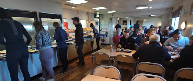
That's not because we're concerned that it isn't going to happen: you can usually count on there being food at the serving hatch three times a day on a regular schedule, and left-overs in the fridge on the mess deck if you get hungry in-between meals, or if you're working overnight.  No, it's mostly because for much of the expedition, the change in food is one of the only ways to tell the days apart.  Once the initial excitement and chaos of starting an expedition dies down, the equipment all gets installed and calibrated, and the data starts flowing, there's usually a very steady rhythm of life at sea.  You wake, eat, do some science, eat, do some more science, eat, meet to coordinate tomorrow, exercise, and sleep (not necessarily in that order).  And then repeat.  And repeat again.  After a remarkably short time, you lose track of what day it is (although you always know what the date is, for recording events in the log!).


So most of the time, the only thing that really changes to distinguish, say, Monday from Saturday, is the food.  And after you've been out for three or four weeks, working on the back deck all day without a weekend or a day off, or sitting in front of the sonar displays for eight hours a day, the highlight of the day - the thing that gets you through one more deployment, or another night of watch - can be what's on the mess deck table.  On Oden, for me, it's Thursday night dinner: traditional Swedish ärtsoppa (pea and ham soup) with mustard and rye crispbread, followed by pancakes with lingonberry jam and ice cream.

Wednesday, August 14, 2024

An Explorer’s Club Flag and Rolex Expedition

 Written by: Larry Mayer


All my life I have enjoyed going to sea.  It was what drew me into oceanography and what has sustained me though the sometimes bureaucratic and frustrating aspects of academia.  I have been privileged over the years to have taken part in almost 100 research cruises, travelling to all parts of the world, addressing fundamental scientific questions and hopefully contributing to a better understanding of our planet.  And while it has been the pursuit of answering important scientific questions that has driven me, I must admit that what also led me into sea-going ocean science was the recognition of how little is known about our oceans and that their study was also a very pure form of exploration. 

Nowhere is the combination of science and exploration more evident than in our missions to the high Arctic, and particularly our current mission, where we are mapping and making measurements critical to our understanding of the melting of the Greenland Icecap and the rise in global sea level, in areas where no ship has ever gone before.

It is in the spirit of science and exploration that we were honored to learn that our GEOEO24 Expedition was selected as an Explorers Club Flag Expedition. The Explorers Club is a world-renowned professional organization with the goal of promoting scientific exploration and field study.  The Club has endorsed flag expeditions since 1918 and the flags have been carried on every continent, to both poles, to outer space and to the depths of the oceans.   There are currently 222 numbered flags, each with a unique history.  We have been issued Flag Number 35 which interestingly first was issued in 1930 to a University of Michigan expedition to Greenland.  Since that time, it has been to the highest mountains of Pakistan, to the jungles of Bolivia, the Okavango Desert in Botswana, the Maliau Basin in Malaysia, to the top of Mount Everest and Mt Mamasa in West Sulawesi and it was carried by Mensun Bound when he discovered the remarkably intact wreck of the Shackleton’s Endurance in the Weddell Sea.  

There are four of us on board the ODEN who are members of the Explorers Club – Martin Jakobsson and Love Dalen from Stockholm University, Liz Weidner, our blog’s host, who recently got her PhD from University of New Hampshire and will soon be taking up a faculty position at University of Connecticut and me, Larry Mayer from University of New Hampshire. 

Not long after we received the news of our selection as a Flag Expedition, we received more exciting news from the Explorers Club – we had also been selected as an Explorers Club Rolex Expedition, where the Club and Rolex provide a Rolex chronometer to worn during the expedition.  For those like me who usually wear an inexpensive watch, it is both thrilling and a bit intimidating to wear a Rolex watch – but it is an opportunity and an honor hard to pass up.

We are now about a week into the cruise – we have been pushing north through Nares Strait – mapping the seafloor continuously and stopping to make measurements of the water temperature structure along the way and to take core samples from the seafloor.   We have also been deploying land teams by helicopter who have been sampling ancient drift wood (to understand past circulation patterns), mapping and sampling the geology (to understand the tectonic history of the region) and collecting animal bone samples for DNA studies.  All these studies will be combined to get a more complete picture of the history of climate in the region and to better understand the current rapid changes in melting of the icecap.  Our ultimate goal is Victoria Fjord where, if the ice allows us, we will spend several weeks doing detailed studies of the melting processes of the icecap.   We have run into very heavy ice today – and are already thinking about contingencies – but a lesson long-learned in the Arctic is that patience and flexibility are essential.

Tuesday, August 13, 2024

Traveling to the Top of the World

Pituffik US Space Base sits at 76.32 N, well within the Arctic Circle in Northwest Greenland. It was here we landed on August 7th after more than 50 hours of travel to board Icebreaker Oden for the GEOEO24 expedition. Between the three members of the GEOEO24 US contingent (Liz, Brian, and Larry) that travel included six countries, nine plane flights, a train ride, three buses, and one small boat transfer. After trials that included lost luggage, ambient noise levels in excess of 109.9 dB re 20 µPa, and an unexpected stay in Iceland we arrived in the land of the midnight sun. All-in-all it was a relatively straightforward trip, given our past experiences getting to polar expedition starting points!

We started from our respective homes in the US and flew to Stockholm, Sweden to meet the rest of the GEOEO personnel, both scientists and the ship’s crew - Oden did a full crew transfer from those involved on the transit from Helsingborg to Pituffik to GEOEO24. After meeting bright and early at Arlanda International Airport, we boarded a Swedish Airforce Hercules C-130 cargo plane headed for Greenland, by way of Iceland for refueling. While the name “Hercules C-130” suggests a huge transport, the reality was quite cramped. The 75 passengers (52 scientist and 23 crew) pushed the Hercules capacity to the limit!


C-130s are cargo planes and typically that cargo is not people. There is very little sound damping and no creature comforts (definitely no inflight service). Brian measured the ambient sound levels at cruising altitude at more than 109.9 dB re 20 µPa – very loud indeed! Almost everyone wore earplugs and noise canceling headphones. Some of us tried to nap, some of us read, some of us day-dreamed about the sauna on Oden. After a very long, loud four-and-a-half-hour flight we landed in Keflavik, Iceland for the planned refueling.

This was where our drama really began. We had to disembark for safety reasons, and while waiting we learned that the second left of our flight was canceled due to poor weather at Pituffik. We would have to stay the night in Iceland. Imagine trying to find a last-minute hotel for 75 people… But that’s not all! We returned to the Hercules to pick up our gear and discovered that several pieces of luggage (including Larry’s bag) had not been loaded onto the flight!! Imagine, if you will, going to sea for 40+ days without your carefully packed gear (cloths, toiletries, books, snacks). It was a nightmare!!

Now we must introduce the hero of this story: Asa Lindgren, who works for the Swedish Polar Research Secretariat (SPRS) which is the governmental body dealing with the administrative details of the GEOEO24 expedition. She and her team found us a hotel and transport within the hour, all the while making phone calls to locate the missing luggage. After checking into our hotel, the US contingent (plus a few others) took a field trip with Larry to downtown Reykjavik to purchase some backup clothes and toiletries, just in case the luggage was well and truly lost. Unfortunately, it just happened to be a public holiday, Commerce Day (like Labor Day in the USA), and most the shops were closed. Seemed like Larry’s luck had really run out…

Fortunately, the luggage was found and delivered to the airport 15 minutes before our flight took off the next day. We all cheered as it came onboard and then finally took off for the second four-and-a-half-hour flight to Pituffik, Greenland. 

Pituffik Space Base sits in is a barren, beautiful area in northwestern Greenland. The hills are brown and tree-less, with some lingering snow even in the middle of the summer. The edge of the Greenland icesheet is visible in the distance, the termini of several glaciers a visible reminder of the changing climate in the area. Anchored offshore was Icebreaker Oden, our final destination. We were processed through the Space Base with quick efficiency and bussed out to the pier for our small boat transfer and (finally!) the beginning of GEOEO24. 

Photo by Brian Calder


--

The Hours In-Between

Written by Liz Weidner Going to sea is an amazing experience. Being on Oden in Greenland? Even more so. On more than one occasion Brian has ...